


To
The Chief Justice of High Court at Hyderabad
On southern banks of Moosi Nadi
Adjacent to heritage building Government City College,
Hyderabad
Dear Chief Justice garu,
Subject: 3747 Komati Kunta, Gopanpally, Serilingampally, RR District, Telangana – encroachments inside FTL & Buffer zone, inflow and outflow channels razed. Appeal for restoration of the water body lifeline for use of people and biodiversity in the vicinity of the lake.
Reference: Information on HMDA Lakes given on HMDA website
FTL & Cadastral maps
Date of preliminary notification: 23.07.2014
Date of Final notification: NIL
May God Bless you for protecting the lifelines of Hyderabad to sustain life of present and for future.
We draw your prompt attention to the HMDA lake ID 3747 Komati Kunta, Gopanpally village, Serilingampally Mandal, RR District, Telangana.
A. Digital survey thru historical satellite imagery from Google Earth:
We have overlaid the officially demarcated geo-coordinates on Google Earth to arrive at the officially demarcated FTL boundary of the Komati Kunta, from data given in HMDA uploaded here.
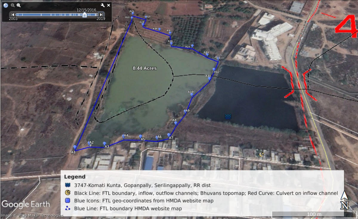
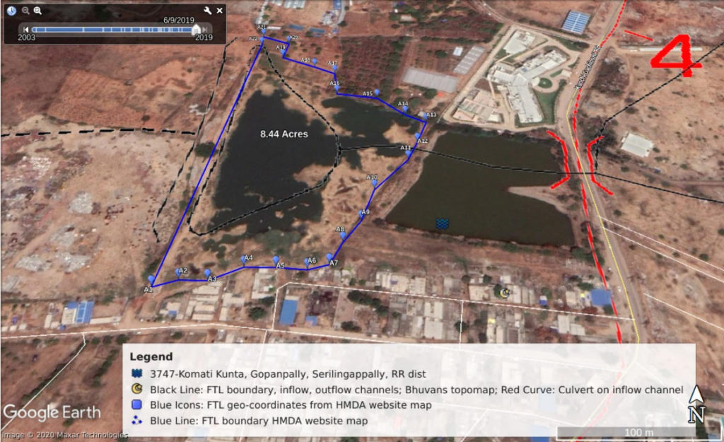
A1. FTL geo-coordinates mapped on the latest Google Earth satellite imagery dated 9 June 2019. The black lines indicate the HMDA lake ID 3747 Komati Kunta hydrology with inflow and outflow channels. Red curves indicate culvert across the inflow channel. While blue icons indicate the officially demarcated FTL geo-coordinates from A1 to A22, the blue line joining these FTL geo coordinates indicates officially demarcated FTL boundary of the lake.
Encroachments include those conspicuously observed on the southern part of FTL boundary and its buffer zone.
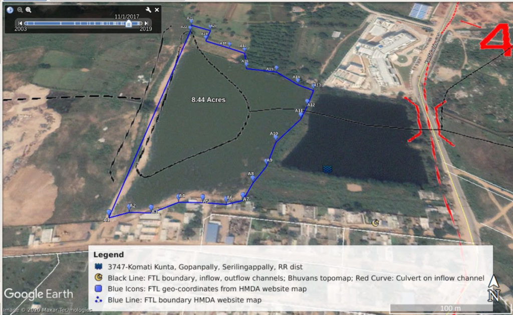
A2. Below satellite imagery of 1 November 2017 indicates wide water spread after the incessant rains of October-November 2017. There are a number of encroachments in the FTL boundary and buffer zone and lake measurements seems to have been compromised to accommodate the encroachments.
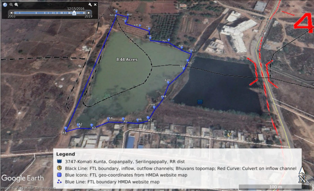
A3. Below satellite imagery of Komati Kunta dated 15 December 2016 after incessant rains in 2016. There is maximum spread of the lake and number of encroachments in FTL boundary and buffer zone and lake measurements seem to have been compromised to accommodate the encroachments.
B. Digital survey through Indian geo-platform of ISRO from NRSC National Remote Sensing Centre:
Below screen shot from Indian Geo-platform of Indian Space Research Organization indicates water spread much beyond the officially demarcated buffer zone.

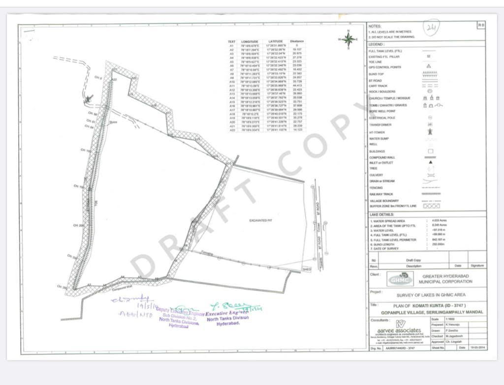
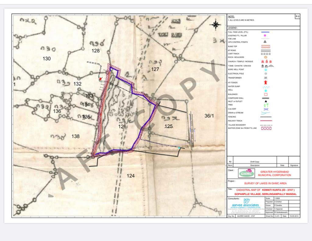
C. Below are GHMC Irrigation signed maps of lake ID 3747 Komati Kunta from HMDA website :
C1. FTL map of lake ID 3747 Komati Kunta. Geo-coordinates, as given in this map below, were used to overlay FTL boundary on satellite imagery of Google Earth to observe the historical water spread during peak rains as well as to find out encroachments:
C2. Cadastral map of lake ID 3747 as downloaded from HMDA website. Officially demarcated FTL boundary has been overlaid on the village map. While these indicate the extent of the lake as per survey numbers, it is overlaying of the officially demarcated geo coordinates on satellite imagery that gets us the ground realities on the extent of the water body devoured through official ommissions and commissions.
D. Google Drive link of all relevant documents for ready reference of the Chief Justice for rendering justice:
D1. This link gives access to all documents that we have used in filing this appeal before Chief Justice of High Court at Hyderabad for the restoration of lake id 3747 Komati Kunta, including its buffer zone, the inflow and outflow channels along with the buffer zones of the channels.
D2. We also give the link to the .kmz file derived from the officially demarcated FTL geo-coordinates. This file opens on Google Earth and helps Chief Justice to read FTL boundary and traverse across the historical imagery of the Komati Kunta from present to 2003.
E. Prayer:
1. Eviction of encroachments observed in FTL boundary and the Buffer zone including in southern part of the lake, and restoration of 3747 Komati Kunta as designated potable water resource for demarcated vicinity of the population with proper scientific and social advice from Serilingampally WALTA authorities, RR District WALTA authorities, Telangana State WALTA authorities & Lake Protection Committee;
2. Outflow channels, inflow channels and culvert identified as per Bhuvan’s topo map are to be identified and protected;
3. Lake needs to be fenced at the buffer zone boundary of the lake; inflow and outflow channels as identified in Bhuvans topo map and ISRO map need to be restored, a buffer zone to be demarcated and fenced at the buffer zone;
4. The buffer zone of the water body and the channels to be biologically fenced with the scientifically notified plantations, that benefit the lakes and its waters. Buffer zone to be maintained pervious (non-concretized) in a gradient manner with full flow of rain waters allowed from catchment into the lake.
F. Please render justice to water bodies of Hyderabad as basic human fundamental right for all forms of life:
1. This, the High Court at Hyderabad is the threshold from where following standards of care was endeavoured for water bodies as in SUO MOTU WRIT PETITION NO: 15595 of 2006:
“for not allowing water tank/tank bed or land described as “Cheruvu” be put to any other use by any public authority or private individual or is allowed to be used for any other purpose.”
2. Further, WALT Act 2002 lays down as follows:
“23. (1) The authority may notify water bodies like lakes, village ponds and minor irrigation tanks along with nalas (watercourse or drainage course) as heritage bodies and conservation areas to prevent the conversion of their intended use and the authority shall take all measures to permanently demarcate the boundaries through the department of the Government or the organization concerned as per the memoirs of lakes/tanks/ponds / nalas (watercourse or drainage course) and shall take measures to evict and prevent encroachment. For this purpose, the Authority may give directions to the concerned department, agency, statutory body or official and upon such direction, the concerned department, agency, statutory body or official shall comply with such directions. The authority may also issue guidelines in this regard and the guidelines shall be complied with by all the concerned. (2) The designated officer shall have the power to prevent and remove encroachments into the demarcated area of the water body. (3) No undesirable wastes including liquid wastes shall be allowed to be dumped in the water bodies by any person or organisation…(5) The designated officer shall have the authority to take required steps to prevent and control polluted water entering the water bodies…
34. (3) Any action or act done by any public servant in the absence of good faith as determined by the Authority shall not be covered under the protection given under sub-section (1) and section (2) and such public servant shall be deemed to be guilty of the offence and shall be liable to be proceeded against and punished accordingly.”
3. As per the Supreme Court orders from time to time on Article 21 of right life with dignity and of change of land use of water zone, that can never be done. In Hinch Lal Tiwari vs Kamala Devi And Ors on 25 July 2001 Bench: Syed Shah Quadri, S.N. Phukan in Appeal (civil) 4787 of 2001, Supreme Court said as follows:
“The Government, including the Revenue Authorities (i.e. Respondents 11 to 13) having noticed that a pond is falling in disuse, should have bestowed their attention to develop the same which would, on one hand, have prevented ecological disaster and on the other provided better environment for the benefit of the public at large. Such vigil is the best protection against knavish attempts to seek allotment in non-abadi site.”
“Further, it will also help in maintaining ecological balance and protecting the environment in regard to which this Court has repeatedly expressed its concern. Such measures must begin at the grass-root level if they were to become the nation’s pride.”
We trust earliest render of justice.
Best,
Dr Lubna Sarwath, Dr Jasveen Jairath, Balaswamy Gurram
Dr Lubna Sarwath
Socialist Party (India), Telangana State General Secretary
Voter ID (old): WRH0435222
Voter ID (current): WRH22446229963002403
Hyderabad


